

Working with raster imagery doesn’t have to be complicated. Geographic Imager® mapping software enhances Adobe Photoshop to make working with spatial imagery quick and efficient. It adds tools to import, edit, manipulate and export geospatial images such as aerial and satellite imagery. Enjoy the use of native Adobe Photoshop functions such as transparencies, filters, pixel editing, and image adjustments like brightness, contrast, and curve controls while maintaining spatial referencing.
Mosaic and tile images, transform projections, georeference and rectify images using an easy and interactive workflow. Batch-process your imagery using Geographic Imager and Adobe Photoshop scripting capabilities. Geographic Imager supports GeoTIFF in Adobe Photoshop and many other industry standard raster formats. Geographic Imager has the ability to create map packages fully compatible with the Avenza Maps app for iOS and Android. Map publishers who sell maps can upload map packages directly to the Avenza Map Store. Geographic Imager is a great companion to MAPublisher for Adobe Illustrator—prepare images in Geographic Imager and use them in MAPublisher. Geographic Imager is also available in a Basic license.

Feature Highlights
Import
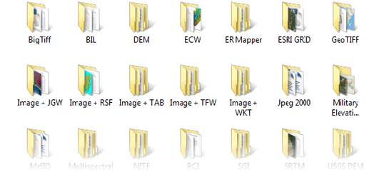
Any image format that can be opened and displayed by Adobe Photoshop can form the basis for a spatial image. Import common spatial formats such as GeoTIFF, MrSID, NITF, PCI and more. Import digital elevation formats such as Esri GRID, BIL, and USGS DEM. Preview images and resample using Advanced Import to save memory and time. Note: Some limitations apply to certain formats. Full details and to see all the Geographic Imager supported formats.
Georeference
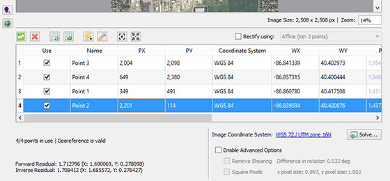
Georeference images easily by adding control points and assigning world coordinates interactively. Review residual errors and detect coordinate system to reference and rectify images. Manually add control points, import or export points from a text file, and view accuracy and errors. Use the Quick Georeference option to make georeferencing even easier. Multiple transformation types are supported.
Transform
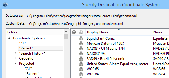
Extensive support for thousands of geographic and projected coordinate systems. Easily transform between geodetic and projected coordinate systems. Need to define your own coordinate system? Create one or edit an existing definition and save it for future use. Manage custom transformations in an easy to use coordinate system browser.
Mosaic &Tile
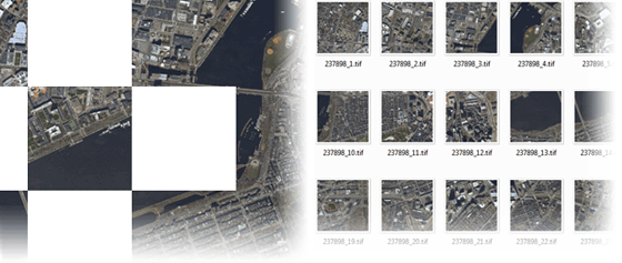
Snapping images together not working? Mosaic individual images to create a seamless image. Mosaicked images retain spatial referencing and can be individually modified using Adobe Photoshop tools and transformed using Geographic Imager. Also, tile an image into multiple images by tile size or count and automatically save them using sequential naming. Tiles retain spatial referencing making it ideal to import into MAPublisher without any trouble.
Geographic Imager Features
Geographic Imager Panel
Now fully compatible with Adobe Photoshop Creative Cloud 2017, the Geographic Imager® panel provides access to all the tools and functions quickly and easily. All spatial information related to a GeoTIFF, DEM, ECW, MrSID or other supported image including the coordinate system, world location of the corners and pixel size are displayed along with buttons to access Geographic Imager tools. Convenient tabs in the panel provide access to vital image information and the ability to copy values to the clipboard. More time is left to edit geospatial data rather than searching for tools.Dark and light panels match the Adobe Photoshop interface
Retain Spatial Properties
Geographic Imager allows the use of Adobe Photoshop native functionality without destroying the spatial properties of spatial images. Easily manipulate and adjust the visual elements such as colour values and levels, histograms, hues and sharpness. Spatial properties of the image are automatically updated and retained even after performing crop, rotate or geospatial adjustments. This is important in industries such as photogrammetry and remote sensing where it is necessary for analysis.
Georeference Imagery
Import or add ground control points for accurate georeferencing of aerial photography or satellite imagery with multiple transformation types supported. Georeference with the aid of an online map to match control points with real world coordinates. Assess residual errors to improve geoferencing and detect coordinate system to reference or rectify images to. Quick Georeference by a single tie point, two tie points, or from other documents.
Import and Export Spatial Imagery
Import and manage georeferenced imagery in Adobe Photoshop such as GeoTIFF, NITF, MrSID, PCI and other compatible raster data formats, including support for CIR, RGBI and other multispectral and multichannel data. Quick Save feature allows you to quickly save to popular geospatial formats. See a complete list of supported formats.
Advanced Import
Import multiple files of differing formats (drag and drop supported). Connect to Esri’s ArcGIS Online and import image layers and data from web services. Resample and crop large images to quicken the import process. In addition, mosaic and import images as layers into existing documents, specify and adjust DEM and DTM information and combine multiple DEM files on import.
Useful for remote sensing, modify bands/channel color mapping and select specific channels to import for multiband/hyperband images.
Export Web Tiles
Use the Export Web Tiles feature to generate image tiles that can be used for online map purposes.
Google Maps, OpenStreetMap, and TileMill formats are supported. Included with the tiles is an HTML file that can be further edited to fit your online mapping solution. See more formats.
Geospatial PDF support
Create Adobe Acrobat PDF files containing coordinate systems from Geographic Imager image or import and modify existing Geospatial PDF documents. Easily share or publish them online. Find locations, measure distances, perimeters and areas, add locations markers and customize export settings.
Export to Avenza Maps and Upload to Avenza Map Store
Create map packages from your documents that are compatible with the Avenza Maps app for iOS, Android, and Windows. Map packages are pre-processed specifically for the Avenza Maps app. An Avenza Map Store vendor can upload map packages directly to the Map Store and have them for sale very quickly. Export to Avenza Maps can be included in a Adobe Photoshop batch scripts to process and export hundreds of maps at once.
Import and Export Elevation Data
Import DEM formats such as ArcInfo ASCII Grid, ArcInfo Binary Grid, USGS DEM, Military Elevation Data/DTED and SRTM. Assign a DEM Schema during import for easier rendering. Overlay aerial photography to create custom looking images. Export to grayscale GeoTIFF and USGS DEM formats. See a complete list of supported formats.
Terrain Shader
Create shaded relief maps from DEM data in Adobe Photoshop quickly and easily using the Terrain Shader feature. Control intensity and lighting source. Define elevation intervals for custom colour ramps.
Transform
Extensive support for thousands of geographic and projected coordinate systems with the ability to save custom definitions for future use. Re-center images using a custom central meridian and modify pixel resolution.
Mosaic
Mosaic raster images to create a seamless image. Retain images as separate layers or flatten to create one image. Now supports image transformation during Mosaic, making it easier to get the images the way you want. Also, now create seamless mosaics of images with different coordinate systems, pixel sizes, channels and colour modes.
Tile
Tile raster data into multiple images by tile size or count and automatically saves tiles using sequential naming into any supported spatial image format. Great for turning large satellite images into smaller tiles and serving them online. Now supports the ability to tile DEM images to USGS DEM and grayscale GeoTIFF formats.
GeoCrop
The GeoCrop tool allows image cropping based on a combination of pixels or geographic coordinates (geodetic and projected). Easily define coordinates or draw a crop area to see a preview. Advanced Import allows you to crop images during import, making it a great way to crop large images without the need to open them first.
Channel Management
Use Geographic Imager Channel Management to quickly create false- and true-colour images that retain georeferencing. In addition, Adobe Photoshop Merge and Split Channels are supported. Useful for remote sensing and image analysis.
Measure, Survey and DEM tabs
Improvements were made to the Geographic Imager panel Ruler, Survey and DEM tabs. Measure distances with the Adobe Photoshop Ruler tool and see the results in the panel. Quickly find coordinates and DEM values of points of interest with the Color Sampler Tool and view the results in the Survey tab. Calculate statistics in the DEM tab including range, average and standard deviation.
Automate Tasks
Create scripts and actions of Geographic Imager and Adobe Photoshop tools to automate repetitive tasks. All Geographic Imager tools are compatible with automation.
Licensing
Easily manage license options including commercial, academic, multi-user and floating. New Basic license available! Empower multiple users on a network with cost effective network or floating licenses.
Compatibility
Mac and Windows versions available for Windows 7/8/10 (including 64-bit support) operating system and Mac OS X 10.10 or higher.