

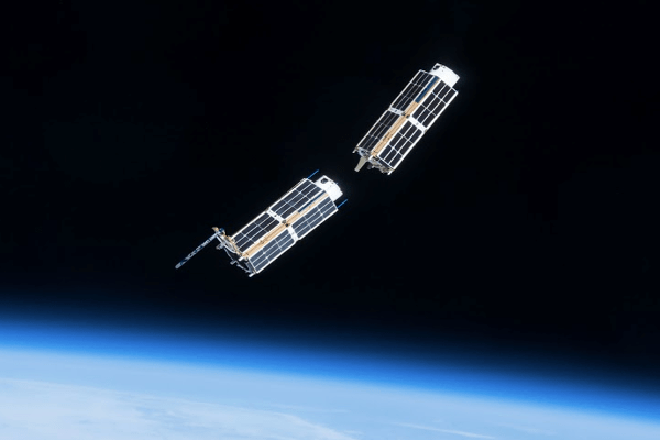
Flock of nanosatellites – PlanetScope is a constellation of innovative satellites designed and built by Planet Labs Inc. To date, they have created and succesfully deployed more than 425 nanosatellites and there are more scheduled to launch by 2022. Every day the PlanetScope fleet images the globe with a coverage of 150 million sq km in 4 spectral bands (B, G, R, NIR) in high resolution (3.0 m resampled). The Planet nanosatellites are nicknamed Doves from their small sizes: 10x10x30 cm at a weight of less than 5 kg!
The next-gen Doves, called SuperDoves, contain 5 spectral bands (B, G, R, NIR, Red-Edge) and 8 bands (bands not published). These satellites will be orbiting and providing deliverables by mid-2020, with final launches in 2021; we can expect 8 band SuperDove imagery by mid 2021.
Planet’s innovative system is designed with a unique approach to accessing and deliverying imagery: in lieu of a standard p2p ordering procedure, the client is given an API key, which allows downloading declared areas of interest in given time intervals. This gives the user more control to set up automated processes.
Planet offer their products in three formats:
- Raw imagery – 12-bits product with radiometric and sensor correction, but without geometry correction (with RPCs provided by producer).
- Analytic product – 12-bits data, delivered as 16-bit GeoTIFF files without colour correction. Product dedicated to analysis purposes.
- Visual product – orthorectified 8-bits GeoTIFF files with colour correction, dedicated to visualisation applications.
Planet imagery is distributed and used by institutions and businesses around the globe, connected with industries in agriculture, forestry, crisis services, environmental protection, spatial planning, defense, monitoring and management of the environment.
PlanetScope satellite imagery ordering options:
| Product | Product Family Subtype | Description | Comments | Delivery | |
| Monitoring | Access | Access newly acquired data and associated meta data, via Planet Explorer, Planet API and desktop GIS, of your AOI(s) for 1 year (or duration of contract). | "Monitoring data" refers to data acquired after contract signing date. "Access" is available as a standalone offer. "Starter Download" for Access is only offered in conjunction with "Monitoring Access" purchase. | API/ Planet Explorer | |
| Access + Starter Download Bundle | Access | Access newly acquired data and associated meta data, via Planet Explorer, Planet API and desktop GIS, of your AOI(s) for 1 year (or duration of contract). Download newly acquired data and meta data within your "Access" AOI(s). For legacy customers only. PlanetScope Monitoring Download (starter, no clipping; charged for first download only) for Enterprise; Single-Entity; Internal Use Rights. | |||
| Starter Download | |||||
| Archive | Access | Access archive data and metadata, via Planet Explorer, Planet API and desktop GIS, of your AOI (s) for 1 year. | "Archive data" refers to data acquired prior to contract signing date. "Access" is available as a standalone offer. "Starter Download" for Archive is only offered in conjunction with "Archive Access" purchase. | API/ Planet Explorer | |
| Access + Starter Download Bundle | Access | Dostęp do danych archiwalnych I metadanych dla zdefiniowanych AOI użytkownika, poprzez Planet Explorer, Planet API oraz desktop GIS. Okres: 1 rok. Pobieranie każdych danych archiwalnych I metadanych w ramach AOI "Access". Tylko dla klientów z ważną umową. PlanetScope Archive Download (Starter, bez docinania - “clipping”; opłaty za pierwsze pobranie tylko). Licencje: Enterprise (Firma); Pojedyncza jednostka; Prawa do użytku wewnętrznego. | |||
| Starter Download | |||||
| Monitoring + Archive | All-Time Access | Access newly acquired data and archive data of your AOI(s) for 1 year (or duration of contract. | "All-Time" is both monitoring and archive data. "Access" is available as a standalone offer. "Download" is only offered in conjunction with "Access" purchase. When purchasing All-Time, "All-Time Download" is only offered with "All-Time Access". Monitoring Download or Archive Download is not supported with All-Time Access. | API/ Planet Explorer | |
| All-Time Access + Preferred Download Bundle | All-Time Access | Access newly acquired data and archive data of your AOI(s) for 1 year (or duration of contract). Download newly acquired data and archive data and metadata within your "Access" AOI(s) PlanetScope All-time Download (preferred (100 sqkm minimum order per scene), with clipping; charged for each download) for Enterprise; Single-Entity; Internal Use Rights. | |||
| Preferred Download | |||||
| All-Time Access + Premium Download Bundle | All-Time Access | Access newly acquired data and archive data of your AOI(s) for 1 year (or duration of contract). Download newly acquired data and archive data and metadata within your "Access" AOI(s) PlanetScope All-time Download Premium (1 hectare minimum order per scene), with clipping; charged for each download) for Enterprise; Single-Entity; Internal Use Rights Note: If AOI is <25sqkm, Premium should be recommended. | |||
| Premium Download | |||||
| * AOI (area of interest) restrictions will be enforced on number of polygons and vertices. Each AOI file shall not have more than 500 vertices and each Licensee can have up to 20,000 vertices. | |||||
Specification
Spatial resolution
3.0 m
Spectral bands
| Instrument Name | Instrument ID | Band | Name | Wavelength (fwhm) | Interoperable with Sentinel-2 |
| SuperDove * | PSB.SD | 1 | Coastal Blue | 442 | Yes - with Sentinel-2 band 1 |
| 2 | Blue | 490 (50) | Yes - with Sentinel-2 band 2 | ||
| 3 | Green | 531 | |||
| 4 | Green II | 565 (36) | Yes - with Sentinel-2 band 3 | ||
| 5 | Yellow | 610 | |||
| 6 | Red | 665 (31) | Yes - with Sentinel-2 band 4 | ||
| 7 | RedEdge | 705 (15) | Yes - with Sentinel-2 band 5 | ||
| 8 | NIR | 865 (40) | Yes - with Sentinel-2 band 8a | ||
| Dove-R | PS2.SD | 1 | Blue | 485 (30) | Yes - with Sentinel-2 band 2 |
| 2 | Green II | 545 (45) | Yes - with Sentinel-2 band 3 | ||
| 3 | Red | 630 (40) | Yes - with Sentinel-2 band 4 | ||
| 4 | NIR | 820 (40) | Yes - with Sentinel-2 band 8a | ||
| Dove-C ** | PS2 | 1 | Blue | 485 (30) | Yes - with Sentinel-2 band 2 |
| 2 | Green | 545 (45) | Yes - with Sentinel-2 band 3 | ||
| 3 | Red | 630 (40) | Yes - with Sentinel-2 band 4 | ||
| 4 | NIR | 820 (40) | Yes - with Sentinel-2 band 8a | ||
|
* Channels 6, 7, and 8 of SuperDove are not available on all PSB.SD imagery. **NIR not available on all PS2 imagery. |
|||||
Revisit Frequency
1 day
Capacity
150 mln sq km per day
Radiometric Resolution
12 bits per pixel
Webpage:
